


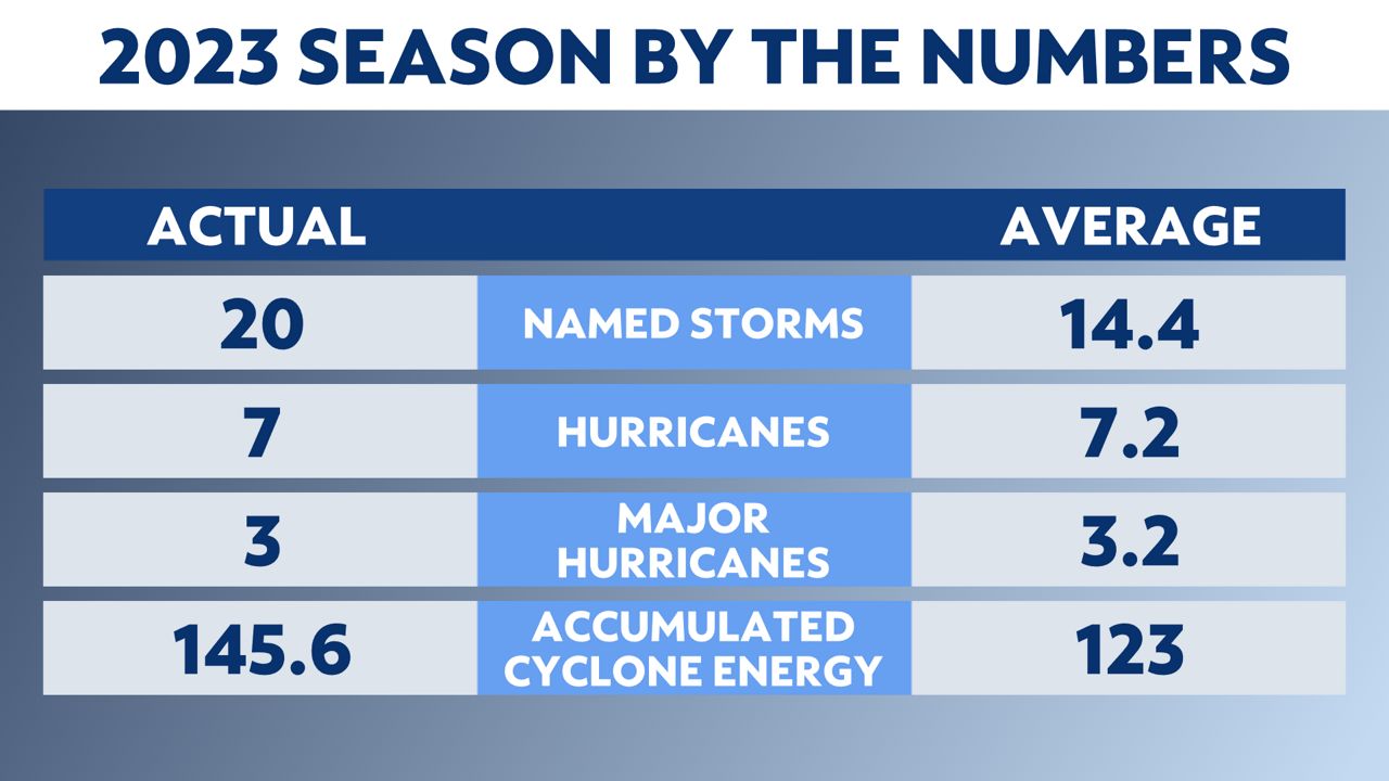
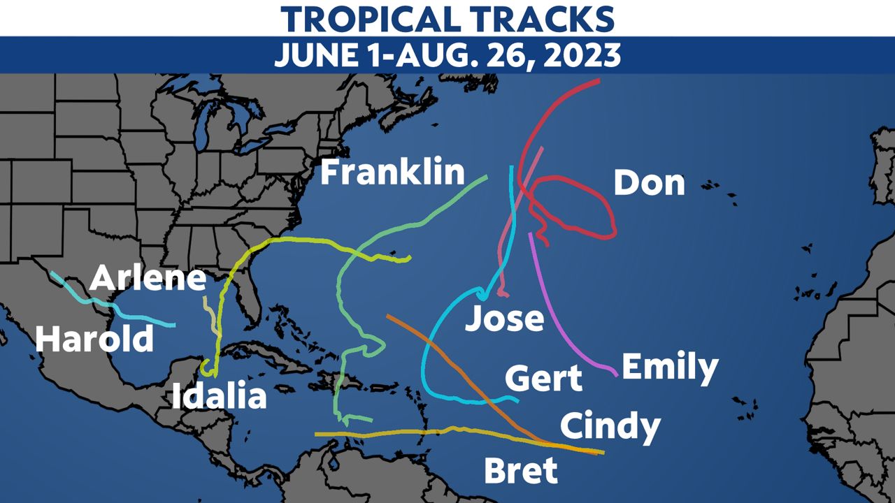
The 2023 Atlantic hurricane season is over. It will go down as the fourth busiest season since 1950 with 20 named storms. Record-warm Atlantic sea surface temperatures and a strong El Niño influenced activity in 2023.
This year’s hurricane season had 20 named storms, seven of which became hurricanes. Three intensified into major hurricanes.
Three named storms made landfall in the U.S., and only one was a hurricane.
Accumulated cyclone energy (ACE) is a measure used to express the activity of individual tropical cyclones and entire tropical cyclone seasons. You can learn more about it here.
Record-warm Atlantic sea surface temperatures likely contributed to above normal activity this season. The warm ocean temperatures provided a counterbalance to this year’s strong El Niño.
Historically, El Niño conditions influence upper-level winds in the Atlantic basin and it suppresses tropical activity. According to NOAA, “the Atlantic basin produced the most named storms of any El Niño influenced year in the modern record.”
Here are the names that were used in 2023. This list, excluding any names that get retired, will be re-used in 2029.

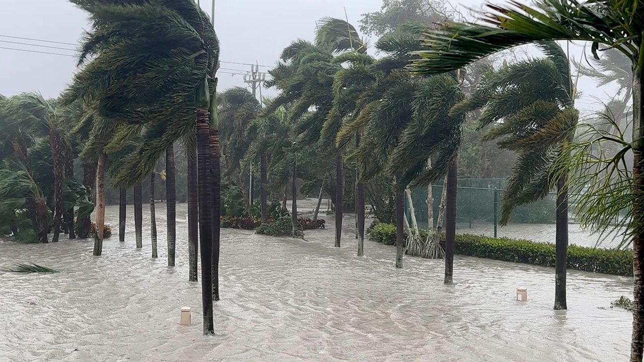
Hurricane Idalia was the only hurricane that made landfall in the U.S. this year. It was a Category 3 hurricane with max winds of 125 mph when it moved inland in Keaton Beach, Fla. on Aug. 30.
The other two named storms that made landfall in U.S. were Harold and Ophelia. Tropical Storm Harold made landfall on Padre Island, Texas on Aug. 22, bringing heavy rainfall to South Texas and northern Mexico.
Tropical Storm Ophelia made landfall near Emerald Isle, N.C. on Sept. 23, bringing heavy rainfall, strong winds and significant storm surge and river flooding to eastern North Carolina.
The other landfalling storm from the Atlantic basin was Lee. Hurricane Lee turned post-tropical before making landfall in Nova Scotia, Canada on Sept. 16. It brought hurricane-force gusts to the Canadian Maritimes and Maine, and also dangerous surf and rip currents across the entire U.S. Atlantic coast.
An unnamed, short-lived subtropical storm formed off the U.S. Northeast coast in mid-January, although the National Hurricane Center didn’t recognize it until May.
It formed on Jan. 16, moving rapidly northeast, making landfall on the far northeastern coast of Nova Scotia just before turning post-tropical a day later on Jan. 17.
At peak intensity, it had top estimated winds of 70 mph. Since the NHC declared it a storm months later during routine reassessment, it did not get a name, but it does count as an official storm.
Arlene became the first named tropical storm of the season on June 2 in the Gulf of Mexico.
Before it became a storm, it was Tropical Depression Two and brought rain and scattered thunderstorms to parts of Florida.
Arlene was short-lived as it headed south toward the Cuba.
Bret formed in the central Atlantic Ocean on June 19, becoming the second named tropical storm of the 2023 Atlantic hurricane season.
Bret fizzled over the Carribean Sea. It brought heavy rain and wind through parts of the Carribean Islands from Barbados to St. Lucia.
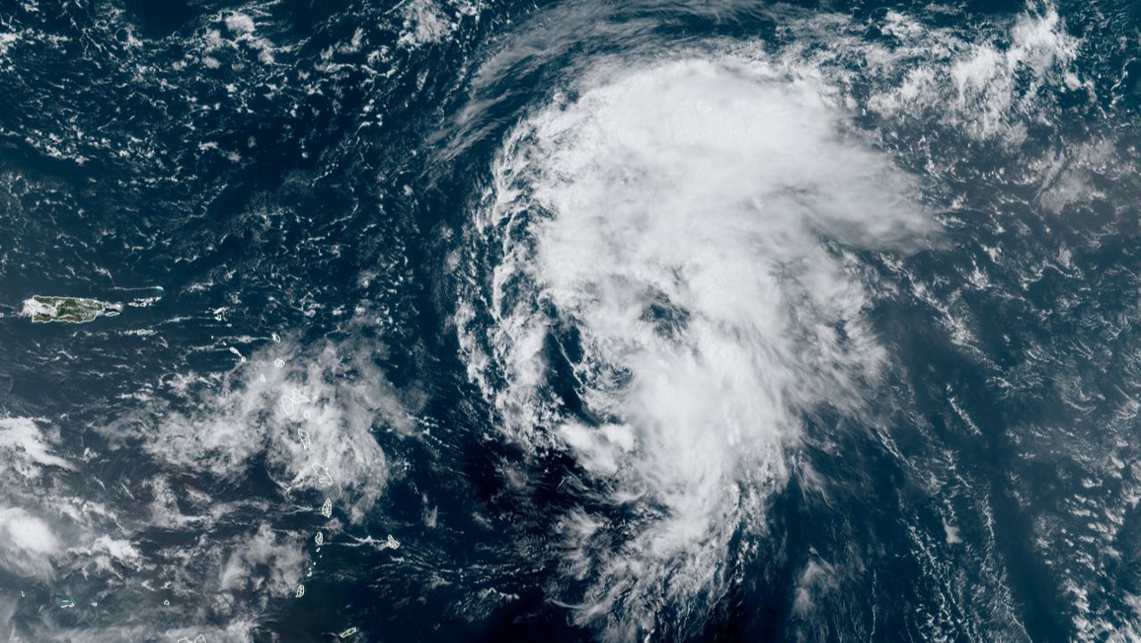
Cindy formed in the Central Atlantic on June 22 and maintained its status as a tropical storm for three days, but gradually weakened thereafter as it combatted increasing wind shear.
It tracked close to the Lesser Antilles but stayed out at sea during its entirety. Its estimated top winds were 60 mph. It finally became a remnant low on June 25.
Don was an interesting storm that didn't want to give up in the Atlantic. It formed on Friday, July 14, becoming the fourth named storm of the 2023 Atlantic hurricane season. After spending its first days as a subtropical storm, Don became fully tropical on July 17.
Don meandered over open water, and as it moved over colder waters, where we expected it to weaken, Don surprised us. It briefly strengthened into a Category 1 hurricane on July 22, becoming the first hurricane of the 2023 season in the Atlantic basin.
It weakened back into a tropical storm again roughly 12 hours later. Don continued on a northeast track before becoming post-tropical on July 24.
Emily was a very short-lived storm, forming into a tropical storm on Sunday, Aug. 20, and becoming post-tropical a day later.
It stayed over open ocean.
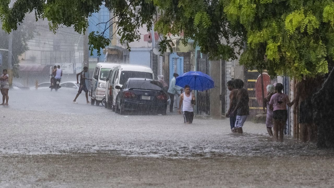
Franklin formed on Aug. 20 in the Caribbean Sea and took a wandering path for several days. It made landfall on the Dominican Republic on Aug. 23. The storm's torrential rain caused flooding and landslides, killing two people.
It gradually strengthened again over the open water of the western Atlantic and became the first major hurricane of the season on Aug. 28. It passed Bermuda on Aug. 30. While Franklin didn't directly impact the U.S., it generated rough surf and dangerous rip currents for a good share of the Eastern Seaboard for several days.
Gert was a "zombie storm" that came back to life after its initial demise. Its first life was in the central Atlantic was brief, forming early on Aug. 21 and dissipating on Aug. 22. It moved west toward the Leeward Islands, but dry air and wind shear helped break it apart before reaching the islands.
The system returned more than a week later in the central Atlantic, redeveloping on Sept. 1. Just like its first life, it didn't last long. Wind shear from post-tropical Idalia tore it apart.
Harold developed in the central Gulf of Mexico early on Aug. 22. It quickly headed west and made landfall on Padre Island, Texas later that morning.

It weakened as it moved over land, but still brought areas of heavy rain to South Texas and northern Mexico.
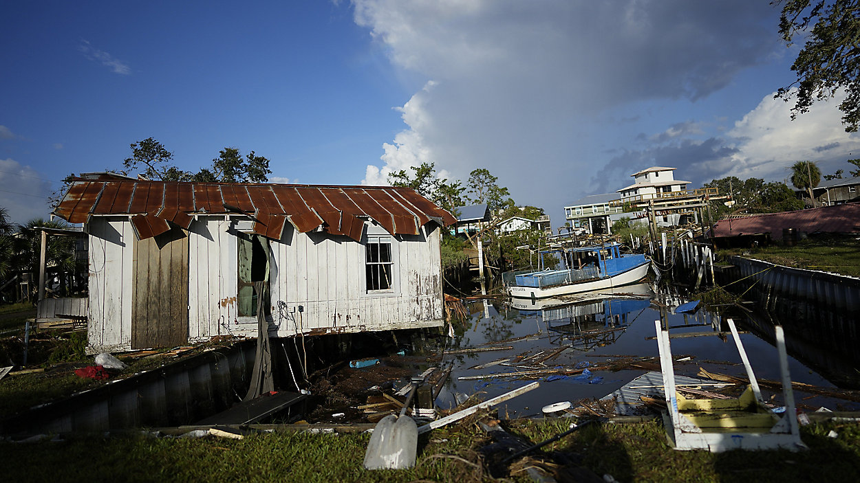
Idalia formed on Aug. 27 in the northwestern Caribbean Sea, where it meandered before entering the Gulf of Mexico. It rapidly intensified there and became a Category 4 hurricane. Idalia weakened slightly before making landfall the morning of Aug. 30 near Keaton Beach, Fla. with estimated top winds of 125 mph. A Category 3 or stronger hurricane had not made landfall in that region since records began in 1851.
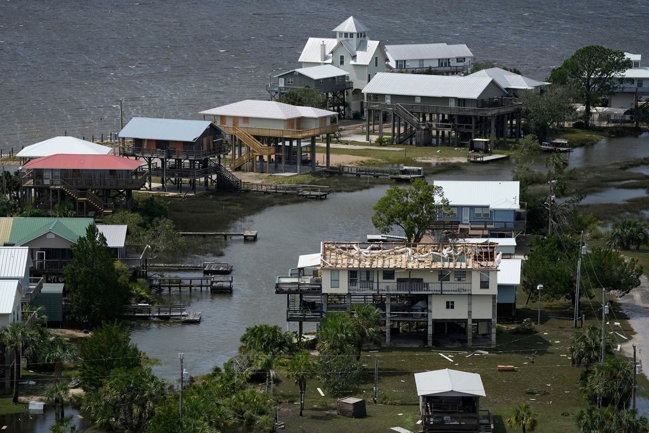
Idalia brought powerful storm surge and flooding rain, and the deluge ran from Florida through southeastern Georgia and into the Carolinas. It became post-tropical on Aug. 31 in the western Atlantic, but still delivered gusty winds and heavy rain to Bermuda as it passed the island on Sept. 2.
Like some other systems this season, Jose was also a short-lived tropical storm. It formed in the central Atlantic well southeast of Bermuda on Aug. 31 but dissipated the next day after being absorbed by Franklin on Sept. 1.
)
Katia was an uneventful and short-lived storm. It became a tropical storm on Saturday, Sept. 2 in the eastern Atlantic. It then weakened into a tropical depression Sunday, Sept. 3. Then it fizzled out on Monday, Sept. 4.
Lee formed on Sept. 5 and became a hurricane just a day later. Lee continued to intensify rapidly as it tracked west, officially becoming a major hurricane on Sept. 7. It became the first Category 5 hurricane of the Atlantic season just hours later, producing top wind speeds of 150 mph.
It stayed well north of the Caribbean, producing dangerous surf and rip currents to parts of the Caribbean, Bermuda, and along the entire U.S. East Coast as it moved north across the western Atlantic as a major hurricane.

Lee turned into a post-tropical cyclone as it moved over cooler waters off the New England coast before making landfall. It made landfall on Saturday, Sept. 16, on Long Island in Nova Scotia, Canada with max winds of 70 mph.
The primary impacts from Lee were felt along coastal parts of New England, Maine, and in Nova Scotia, where Lee brought strong winds, heavy rainfall, dangerous surf and coastal flooding.
Margot spent 10 days roaming over the eastern and central Atlantic Ocean. It formed on Thursday, Sept. 7 near the Cape Verde Islands, and eventually strengthened into the sixth hurricane of the season on Sept. 11.
Margot weakened as it meandered over the open waters of the central Atlantic, becoming a tropical storm again on Sept. 15. It stayed well west of the Azores. Aside from generating dangerous surf and rip currents to the Azores, Margot did not directly affect any land areas.
Nigel formed on Sept. 16 in the south-central Atlantic and made its way northwest before taking a turn to the northeast. During its peak, it became a Category 2 hurricane, but it stayed away from land during its entirety. Nigel became post-tropical on Sept. 22.
Ophelia formed off the East Coast on Friday, Sept, 22, becoming the fifteenth named storm of the 2023 Atlantic hurricane season.
Ophelia made landfall near Emerald Isle, N.C., on Saturday, Sept. 23.
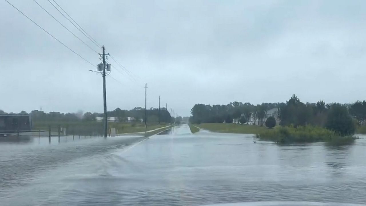
The storm brought heavy rain and gusty winds from the North Carolina coast to the Mid-Atlantic and New England.
Philippe formed over the central tropical Atlantic on Saturday, Sept. 23, and became a tropical storm later that day. It made landfall on the island of Barbuda on Oct. 2, bringing heavy rain and gusty winds to several islands in the northeast Caribbean.
Philippe then tracked north toward Bermuda, but became a post-tropical cyclone just south of the island on Oct. 6. It still brought gusty winds and heavy rain to Bermuda.
The remnants of Philippe affected parts of the Northeast. Maine saw 1 to 4 inches of rain, wind gusts reached around 60 mph and large breaking waves and rip currents hit the coast.
Rina formed into a tropical storm on Thursday, Sept. 28. It briefly intensified the next day, but remained at tropical storm strength.
Its proximity to Tropical Storm Philippe limited Rina's development as it interacted with strong wind shear. It remained over open water and had no impact to land. Rina became a remnant low late on Oct. 1.
Sean became the eighteenth named storm of the season on Oct. 11 in the central Atlantic. It continued northwest over the open ocean.
Dry air kept it on the weaker side, and by early Oct. 16, it dissipated.
Tammy formed on Oct. 18, becoming the nineteenth named storm of the season.
It strengthened into a hurricane before moving over the Leeward Islands a few days later, where it officially made landfall over Barbuda on the evening of Oct. 21. It brought heavy rain and flooding over the Leeward Islands before tracking north.
Tammy peaked in strength on Oct. 25 as a Category 2 hurricane and became post tropical over the open Atlantic early on Oct. 26.
However, on Oct. 27, it regained tropical characteristics and strengthened into a tropical storm again. It maintained its tropical storm status over the next day, but wind shear and dry air eventually lead to Tammy dissipating as it moved well east of Bermuda on Oct. 29.
Our team of meteorologists dives deep into the science of weather and breaks down timely weather data and information. To view more weather and climate stories, check out our weather blogs section.