


After a season brimmed with record activity, the 2020 Atlantic hurricane season has officially come to an end, at least according to the date.
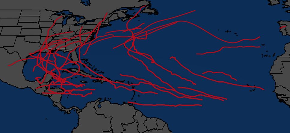
November 30 marks the end of the Atlantic Hurricane season. This year, the Atlantic basin recorded more named storms this year than any other, including the infamous 2005 season.
In total, we tracked 30 named storms and 13 hurricanes, 6 of which achieved major hurricane status.
Here are highlights from the season that we will remember for some time.
Several hours after a depression formed off the Space Coast of Florida, the National Hurricane Center named Arthur a tropical storm on May 16. This marked the sixth consecutive season with a named tropical cyclone before the official start of hurricane season, which is June 1.
The NHC issued tropical storm warnings for the Outer Banks of North Carolina as Arthur headed north.
While never making an official landfall, passing just miles west of Cape Hatteras, the storm brought heavy rain to much of the Southeast. Emergency crews had to rescue dozens of people along the coast due to the rip currents Arthur generated.
Continuing the early start to the season, Tropical Storm Bertha formed on May 27 off the Southeast coast. This marked the third time on record that two named storms formed in May.
One of the shortest tropical cyclones, by duration, Bertha made landfall just east of Charleston, South Carolina, a mere one hour after the National Hurricane Center named it.
With winds of 50 mph and rainfall from the developing disturbance that would become Bertha, the storm racked up over $200 million in damages.

The origins of Cristobal stem from a remnant low of what was Tropical Storm Amanda in the Eastern Pacific. This area of low pressure crossed Central America before emerging in the Bay of Campeche.
Reforming into a tropical storm, Cristobal became the earliest third-named storm on June 5. Two days later, after heading north over the Gulf of Mexico, the storm made landfall near Grand Isle, LA as a tropical storm with 50 mph winds.
While rainfall did cause flooding in parts of the South, continuing north, Cristobal went on to become just the fourth tropical cyclone to reach the state of Wisconsin and the first in over 30 years.
A derecho spawned by Cristobal over the Great Lakes region knocked out power to more than half a million people as powerful winds from a line of thunderstorms blasted through. A derecho is a strong wind storm associated with a line of showers or thunderstorms.

A quick-hitter, Fay developed over the warm waters of the Gulf Stream, just east of the Outer Banks of North Carolina.
Heading north, the NHC issued tropical storm alerts along the Northeast from Delaware to Rhode Island. With winds of 50 mph, Fay made landfall near Atlantic City, NJ on July 10, the first tropical cyclone to make landfall in New Jersey since Tropical Storm Irene in 2011.
Rainfall from Fay led to some road closures, including I-76 outside Philadelphia. Several swimmers lost their lives from rough seas.
Fay racked up over $400 million in damages and was indirectly responsible for five fatalities.
Taking advantage of warm waters, a disturbance moving through the Gulf of Mexico organized enough to become Tropical Storm Hanna on July 23. With just a couple of days before the cyclone would reach land. Based on the models, many meteorologists expected Hanna to make landfall along the Texas coast as a moderately strong tropical storm.
Defying the forecast, Hanna intensified on July 25 and became the first hurricane of the season. The storm continued to intensify right up until landfall, with an eye becoming clear on satellite imagery.
Later that day, Hanna made landfall as a Category 1 hurricane with winds of 90 mph at Padre Island, Texas, about 30 miles south of Corpus Christi.
Damage from storm surge and high wind caused the Bob Hall Pier in Corpus Christi to collapse. Rainfall over a foot in some spots of far South Texas led to flooding and water rescues.
Hanna eventually dissipated as it moved inland over the rugged terrain of Mexico.

Originating as a tropical wave that came off the coast of Africa, the large circulation of what would become Isaias took its time in organizing.
On July 29, Isaias formed as a tropical storm south of Puerto Rico in the Caribbean Sea. Becoming the season's second hurricane a day later, the storm passed over the Bahamas before encountering hostile conditions that caused it to weaken back to a tropical storm.
Isaias scraped the east coast of Florida with tropical storm conditions on August 2.
From there, Isaias traveled north, intensifying back into a hurricane. People along the East coast saw hurricane and tropical storm alerts posted from South Carolina to Maine.
Late on August 3, Isaias made landfall as a Category 1 hurricane with winds of 85 mph at Ocean Isle Beach in North Carolina, about 30 miles northeast of Myrtle Beach, South Carolina.
Strong winds and storm surge damaged homes in nearby Oak Island, NC. Two people lost their lives from an EF3 tornado spawned by Isaias, the strongest tornado from a tropical cyclone in 15 years.
As Isaias accelerated north, impacts spread to the Mid-Atlantic and Northeast.
Isaias was the most impactful wind event in New York City since Sandy struck in 2012. Winds gusted to 78 mph in the city and knocked out power to millions across the Northeast.
The storm continued into Canada before finally meeting its demise.
A traditional long-tracked cyclone, Laura originated off the coast of Africa before heading west across the Atlantic. Tracking through the Antilles, the storm gradually grew more organized, dropping heavy rain that caused dozens of fatalities in the process.
As its path turned toward the Gulf of Mexico, concerns grew of a twin impact along the Gulf Coast between and Laura and Tropical Storm Marco, a growing cyclone already in the Gulf.
While Marco was initially forecast to strike Louisiana as a hurricane, thankfully, the storm weakened significantly before making landfall.
Unfortunately, that wasn't the case for Laura. Taking advantage of ideal conditions, Laura rapidly intensified right up until landfall, becoming an extremely dangerous Category 4 hurricane with winds of 150 mph.
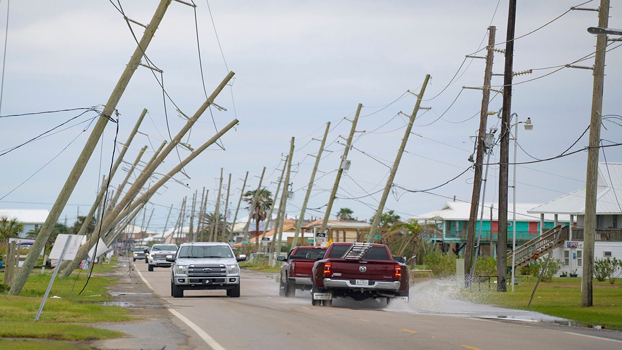
Laura made history, tying with a hurricane from the 1850s, as the strongest storm to ever strike the state of Louisiana. Storm surge inundated coastal communities, leading to a train derailment in Grand Lake.
The costliest storm of the season, Laura caused over $14 billion in damages. Sadly, 42 people lost their lives in the United States, primarily in Louisiana and Texas.

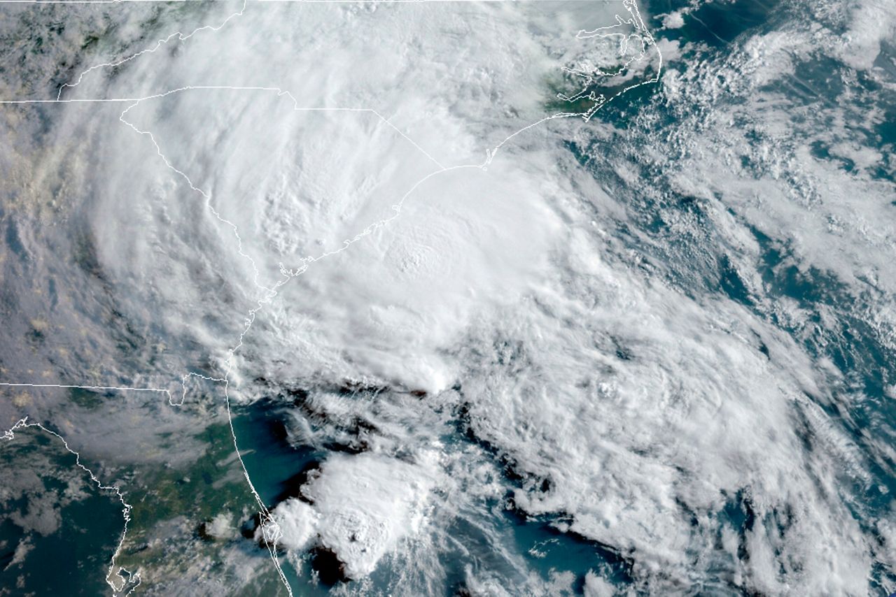
Sally became the first recorded S-storm to form in the month of September and the fifth storm to hit the northern Gulf Coast.
It first developed as a depression near the Bahamas on September 11 during the peak of the hurricane season, then crossed over Florida as a tropical storm a day later. It underwent rapid intensification and peaked at a Category 2 hurricane in the Gulf of Mexico.
Sally eventually made landfall near Gulf Shores, Alabama on September 15 as a Category 2.
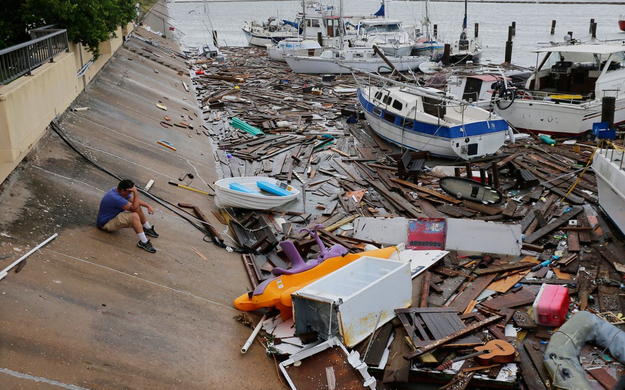
Sally dumped copious amounts of rainfall across the northern and eastern Gulf Coast, with Pensacola, Fla. reaching close to 2 feet of rain. Twenty-two barges broke loose in Pensacola Bay due to the rough waves, with several washing up in the city.
Because of the high waters, raw sewage contaminated cities like Panama City, Fla. and officials advised people living there to fill their bathtubs with clean water they could clean up the sewage.
Sadly, Sally caused nine fatalities, and there was over $9 billion in damage.
It's all Greek to us... again. For only the second time, we used every name on the Atlantic hurricane list and had to turn to the Greek alphabet.
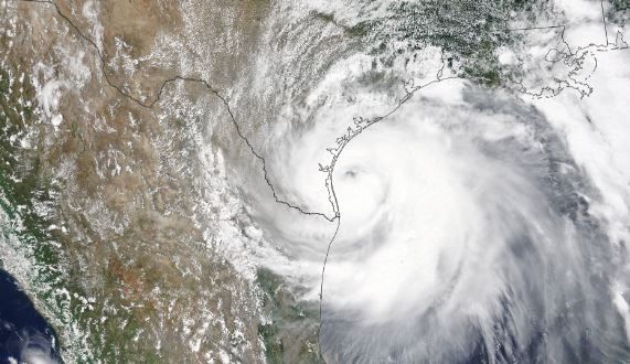
Not long after Sally, Alpha and Beta formed. The latter became a tropical storm on September 18 in the southwestern Gulf of Mexico. It moved north then northeast, where it made landfall as a weak tropical storm in Texas on September 21, bringing heavy rainfall.
Storm surge flooded much of the Texas coast, and Beta destroyed parts of the Galveston pier.
It was only the second time in history where we dipped into the Greek alphabet, the first being the 2005 hurricane season. Beta became the earliest Greek B-storm to form in recorded history.
On the same day, Wilfred and Alpha also formed, making the trio the first in history where three storms formed on the same day.
On October 1, we watched an area over the Lesser Antilles that would soon become Delta.
It wasn’t until October 4 where Delta formed into a tropical storm, once again breaking another record and becoming the earliest Delta to form on record.
Over the next two days, Delta would rapidly strengthen to a major Category 4 hurricane. Luckily, it weakened to a Category 2 hurricane right before landfall on the Yucatán Peninsula.
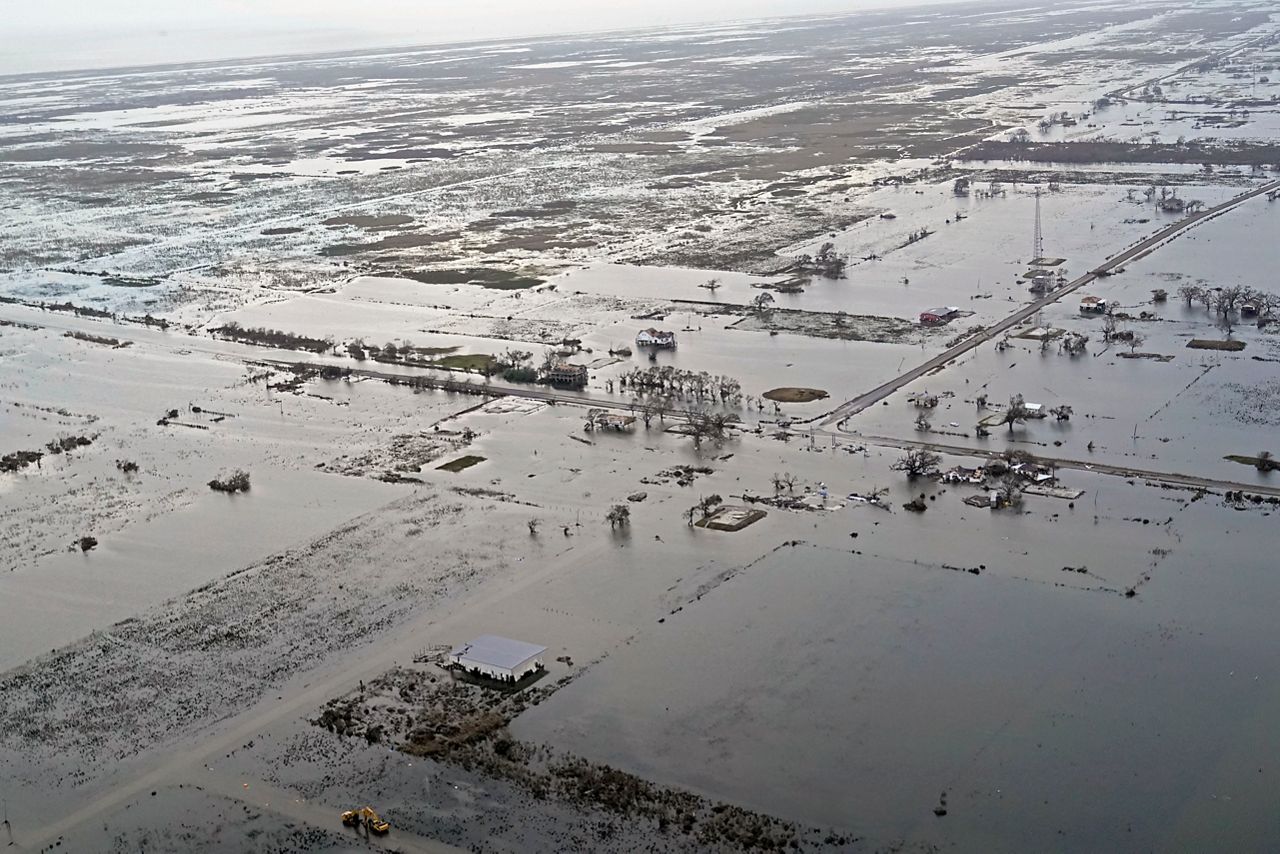
Delta reemerged into the Gulf of Mexico and made its way towards Louisiana, where it would make landfall as a strong Category 2 hurricane near Creole, Louisiana.
It was the sixth time of the season that a storm struck the northern Gulf Coast. Heavy rain, strong winds, and storm surge impacted the coast, with several tornadoes spawning during the storm.
The northern Gulf Coast could not catch a break this season. Zeta became the seventh storm to hit the area.
With how fast the hurricane season was chugging along, it became no surprise that Zeta also became the earliest Zeta to form in recorded history.
On October 25, Zeta became a tropical storm in the Caribbean Sea.
It slowly strengthened and made its first landfall as a Category 1 hurricane along the Yucatán Peninsula.
It moved across the peninsula and reemerged into the Gulf of Mexico where it strengthened into a strong Category 2 hurricane, just 1 mph away from Category 3 status.
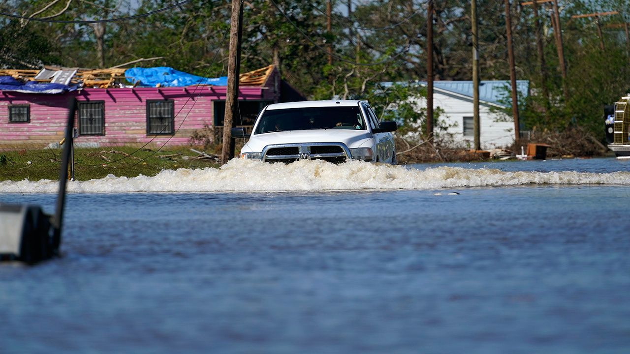
Zeta then made landfall on October 28 in Cocodrie, Louisiana, bringing strong winds and heavy rain. It also crossed the eastern U.S., brought heavy rain and gusty conditions to many cities, left millions without power, and killed six people before exiting into the Atlantic.
Eta was persistent, to say the least, lasting around two weeks and making four landfalls. It also became the only Eta on record.
This storm helped us tie with the 2005 season (the NHC retroactively named a storm after the season ended).
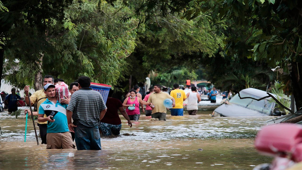
It first formed as a tropical depression on October 31, rapidly intensified, and became a hurricane the next day. Eta continued to intensify, reaching Category 4 status and making landfall in Nicaragua on November 3.
Heavy rainfall led to landslides and many deaths.
Eta weakened and then moved into open waters. It made its second landfall in Cuba on November 9 as a tropical storm, moved into open waters again, made a third landfall in the Keys on the same day, and then stalled in the central Atlantic.
On November 11, it finally pushed north, where it became a Category 1 hurricane, but it weakened to a tropical storm before making landfall near Cedar Key, Florida.
It moved across northern Florida and finally exited into the Atlantic.
Unfortunately, Eta was responsible for over 180 deaths, most in Central America.
Iota broke new records, becoming the first Iota on record and becoming the latest Category 5 storm of any season. Iota also set the record for most named storms in an Atlantic hurricane season. Unfortunately, it was also a powerful storm that made landfall in Central America not long after Eta impacted the area.
First becoming a tropical depression on November 13, Iota was not expected to become the powerful storm that it did. It battled with wind shear, but not long after, won the fight and started to quickly intensify.
In the early morning hours on November 16, around 1 a.m., Iota became a major Category 3 hurricane. Only 40 minutes later, it intensified to a Category 4.
Later that morning, Iota reached Category 5 status, marking the second time a Category 5 hurricane has occurred in November. It weakened by that evening to a Category 4 hurricane and made landfall in Nicaragua.
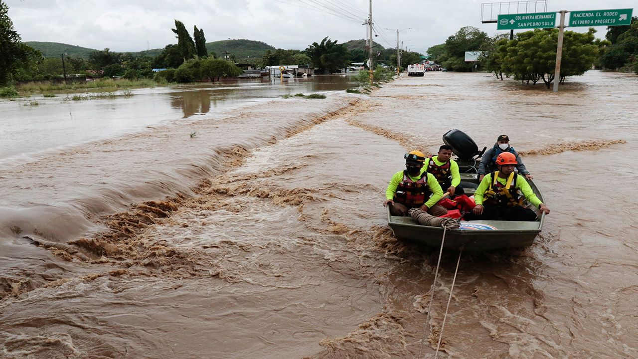
Iota generated very heavy rainfall in an area that was still recovering from Eta. This led to many more landslides and flooding which led to more than 50 deaths, with many more missing. The back-to-back powerful storms left many people homeless.
In addition to the records above, the 2020 season maintained an astounding pace all season long. Almost every storm was the earliest on record.
Theta broke the 2005 record of most named storms in a season, putting 2020 in first place.
We also had the most landfalls this year, coming in at 12.
Through November, the 13 hurricanes remain second all time, only trailing the 15 hurricanes that formed in 2005.
The official season has come to a close, but that does not mean we can't get storms. A tropical cyclone has occurred during every month of the year. So let's just say, these are the 2020 records.. for now.