

The cleanup continues in parts of the southeast after a combination of storms, including the remnants of Hurricane Helene, devastated the area. As of Oct. 7, fatalities have reached the hundreds, with the number expected to rise.
Rainfall totals in the mountains of North Carolina and South Carolina were measured by feet. However, the tremendous amount of rain can’t solely be blamed on Helene. Another synoptic-scale meteorological feature was at play.
Spectrum News Charlotte Chief Meteorologist Jeff Crum explains the unfortunate events, “Days ahead of Helene, we had heavy rain in the region right over the mountains. Some areas had 6-10” and then Helene hit. It was a recipe for disaster.”
The timeline
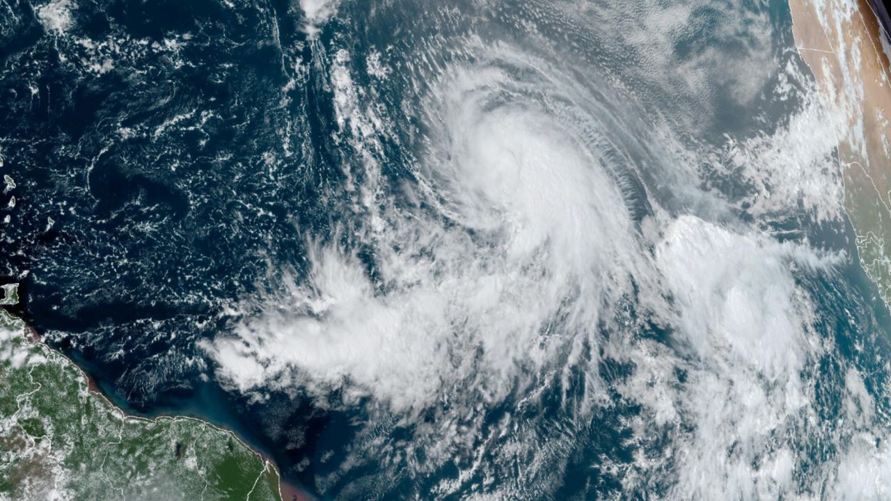
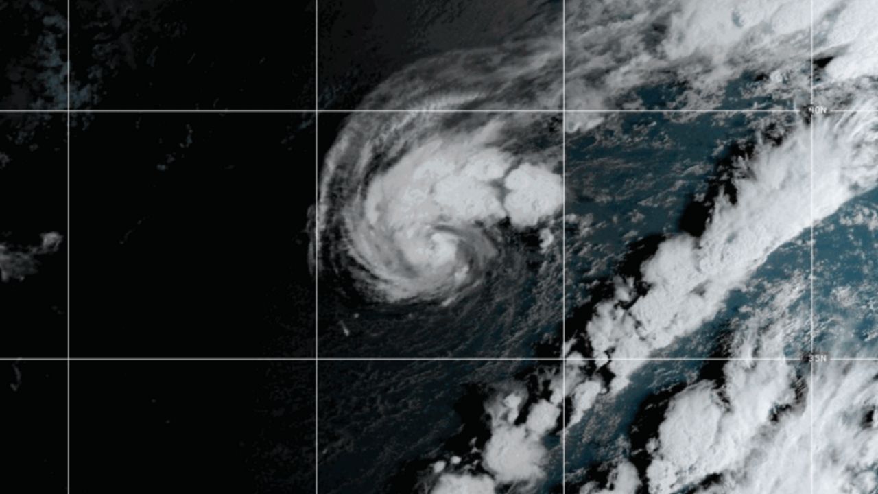
The National Hurricane Center (NHC) noted a region in the western Caribbean Sea on Sept. 17 for possible tropical development. It took a few days for it to become organized, but it began to get its act together and formed a low pressure on Sept. 22. Due to its proximity to land, the NHC designated it as Potential Tropical Cyclone 9 the next day.
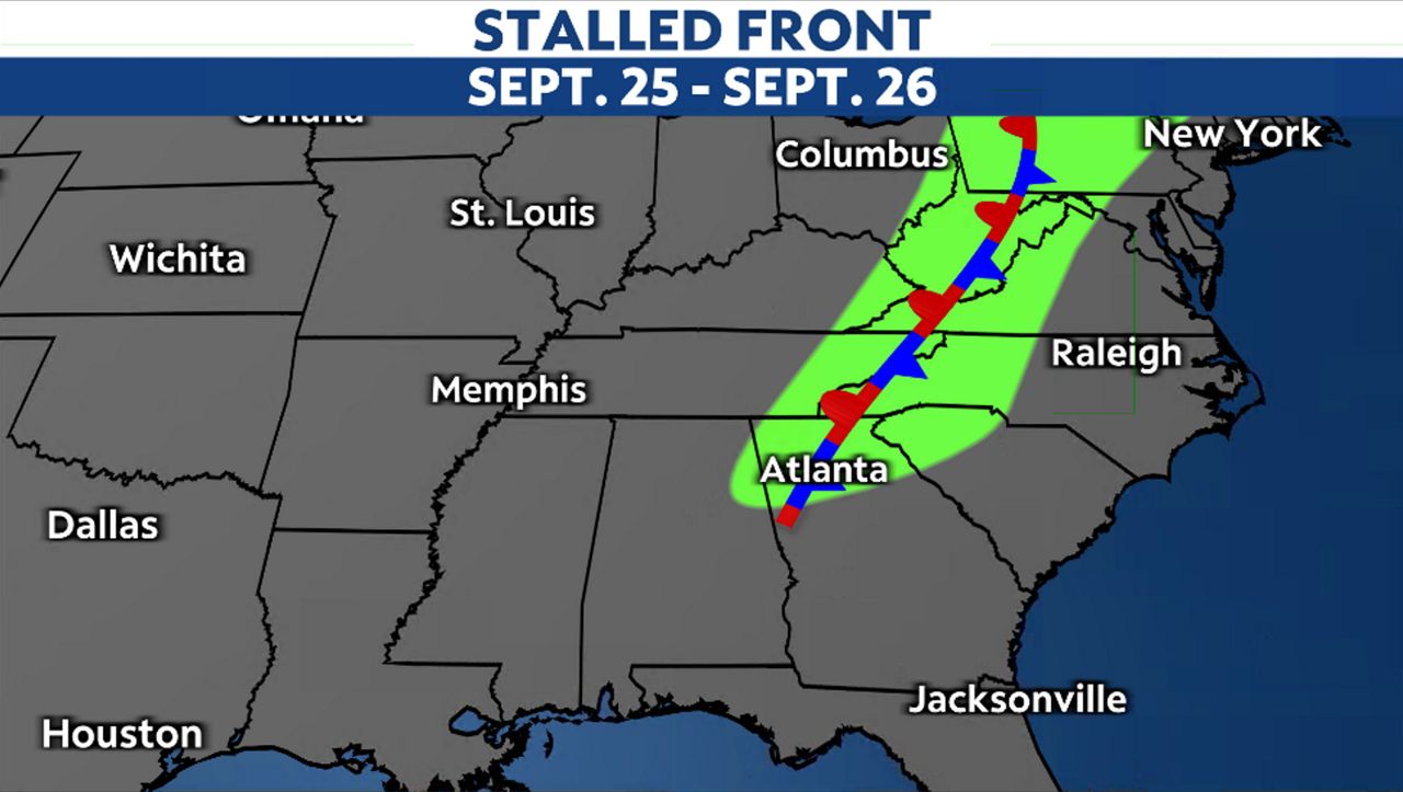
At the same time, a strong cold front was slowly moving through the Midwest. This front was forecast to cross the Ohio Valley and eventually stall along the Appalachian Mountains by midweek.
On Sept. 23, National Weather Service outlets in South Carolina and North Carolina began messaging about the potential impact of a Florida Big Bend landfalling hurricane that could occur in northeastern Georgia, South Carolina and North Carolina Thursday night into Friday.
Crum says, “NWS and our mets, started warning people Tuesday (Sept. 24)/Wednesday (Sept. 25) of the catastrophic potential.”
NWS-Greenville-Spartanburg, SC, messaged “A tropical disturbance over the Caribbean remains unnamed, but is expected to develop quickly into a hurricane by the end of Wednesday before bringing widespread heavy rainfall, flooding and possibly strong wind gusts to our area Thursday night and Friday.” Graphics used displayed the total possible precipitation for this region from Wednesday afternoon through Saturday morning with 4 to 6 inches in Asheville, Nor Car. And upwards of 8 to 10 inches in Tyron, Nor Car.
Rain ahead of Helene
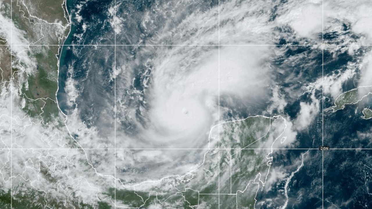
On Wednesday, Sept. 25, rain began falling from the stalled frontal boundary along the Appalachians. Asheville, collected 4.09 inches. The same day, Helene moved into the Gulf of Mexico and was upgraded to a hurricane.
Rain continued to inundate areas along the Appalachians, and before Helene even made landfall, Asheville had already observed nearly ten inches of rain.
Communication is key
NWS was now messaging, “Prepare for catastrophic, life-threatening flooding.” Another message, that same day, contained the language: “This has the potential to be an extremely rare event with catastrophic flash-flooding that hasn’t been seen in the modern era… Numerous landslides expected.”
In a storm like this, Crum says communication is key. How do you reach everyone and explain the impending dangers?
“I think the frustration for the weather community is how that message was disseminated through state and local governments. In the mountains, a lot of folks don’t have the internet, cellphones or satellite TV. They don’t have cable out in the hollers. How in the heck that alert and dire warning was put out beyond what we do is a question for review among sociologists and such.”
Helene's landfall
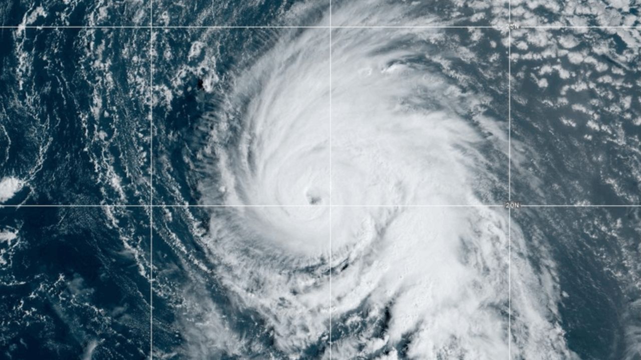
Hurricane Helene made landfall just after 11 p.m. on Thursday, Sept. 26 as a Category 4 with winds of 140 mph along Florida’s Big Bend, near Perry, Fla. Once inland, Helene weakened, but also picked up speed.
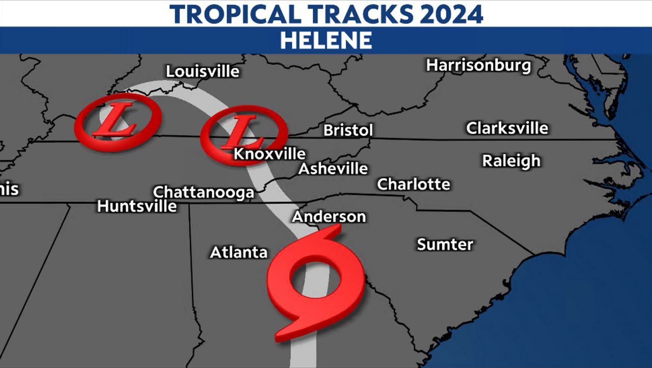
As it moved north in Georgia during the early morning hours on Sept. 27, it was downgraded to a tropical storm. The center of the storm stayed just west of Anderson, South Car. And Asheville, North Car.
This put both areas on the eastern side of the storm. This side, also known as the “dirty side” contains heavy rain and wind. Thanks to the orographic lift and the influences from that stalled boundary, moisture was enhanced.
Another 4.11 inches of rain fell during the morning hours in Asheville. This was on top of the nearly ten inches of rain they had picked up two days prior. Two hours after Helene made landfall, NWS was urging residents to “take action now!” showing a flood inundation map that suggested widespread flooding was forecast in Asheville.
There was nowhere for the water to go. Although the rain ended midday on Sept. 27, the creeks and streams became backed up with many of the rivers not forecast to crest until later that night. A Flash Flood Emergency was issued, indicating life-threatening flash flooding with widespread life-threatening landslide activity expected across the mountains.
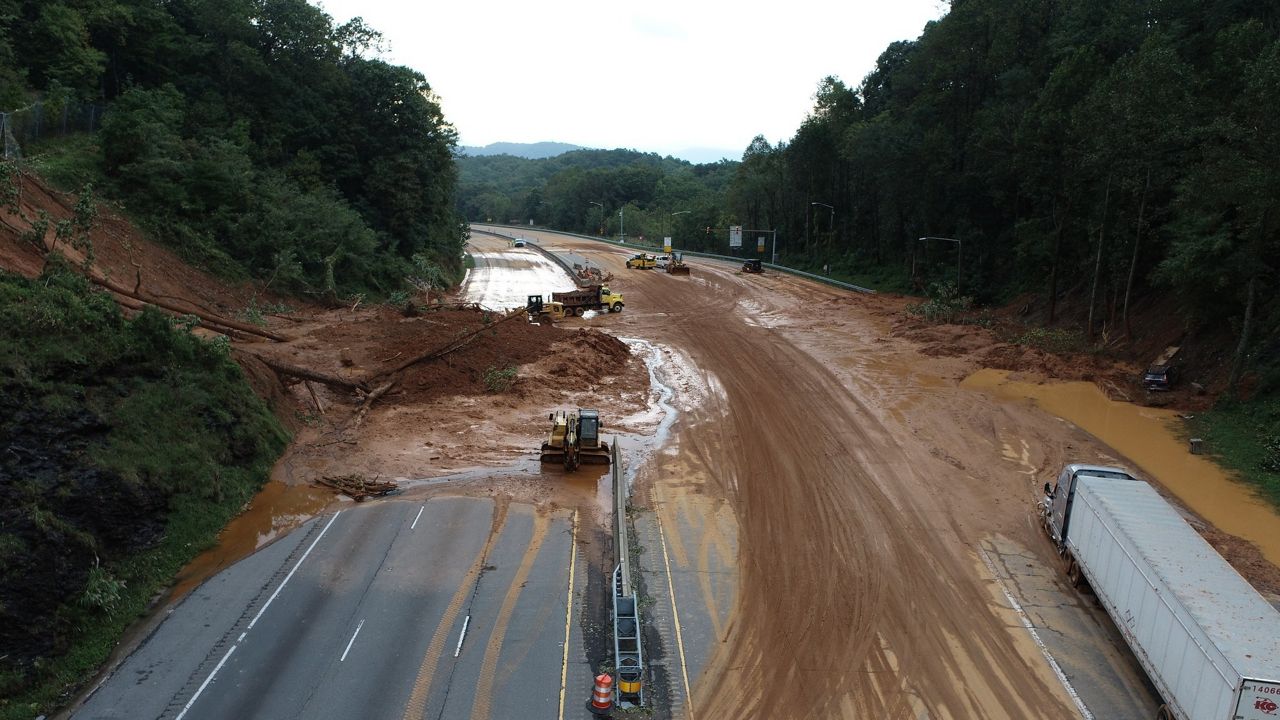
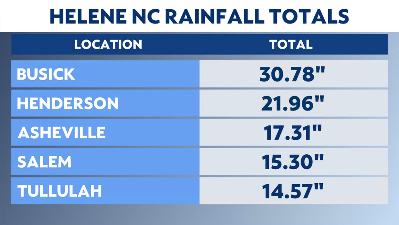
Unfortunately, as seen through pictures and videos, this forecast became a reality and much of the area was devastated. The highest rainfall includes the higher elevations with Busick, North Carolina. picking up 30.78 inches throughout the event.
At the time of this writing, there were still several hundred people missing, with the emotional and financial costs still yet to be tallied. This event will be remembered as one of the worst natural disasters to ever hit the United States, surpassing even Hurricane Katrina 24 years ago.
Our team of meteorologists dives deep into the science of weather and breaks down timely weather data and information. To view more weather and climate stories, check out our weather blogs section.