How Hurricanes Form
Hurricanes happen each year in the Atlantic and they can be the most powerful and destructive storms on Earth. Hurricanes can produce winds in excess of 200 mph, although most produce winds less than 100 mph. Hurricanes act like engines and can be fairly self-sufficient over the open waters. The Atlantic Hurricane Season runs from June 1 through November 30. During this six month period, atmospheric conditions are most capable of tropical development and this is when most named storms occur. Hurricanes can form during the off season but it is fairly uncommon.
What You Need To Know
- Today's lesson is on how hurricanes form
- Items you need for the experiment are below
This lesson will focus on the conditions needed for hurricane development. We will break down the birth of a hurricane into seven simplified steps. First let’s start with the setup.
1. The Setup
The fundamental ingredients needed to start the process of tropical formation involve warm water, light winds, and a humid air mass. The general rule of thumb for water temperature is 80 degrees Fahrenheit for storms to form. These ingredients are most prevalent during the late summer and early fall. This is known as the peak of hurricane season. This is when the water temperature is warmest, the atmosphere is most humid and the upper-level winds are lightest.
2. Rising Air
It’s summer time and the ocean temperature is very warm, 80 degrees Fahrenheit or above. This promotes excessive evaporation adding a tremendous amount of water vapor to the surrounding atmosphere. Warm air is less dense and therefore it rises. As air rises, it cools and condenses into clouds. As this process continues, the clouds grow larger and thunderstorms are born over the ocean. Light winds aloft in the atmosphere allow storms to grow tall without them being torn apart. This is crucial to tropical development.
3. More Thunderstorms
Think about the rising air needed for thunderstorms to form. As the air leaves the surface and rises, the pressure drops because there is less air molecules at the surface. Air flows from high pressure to an area of lower pressure. Outside air begins to rush in to replace the rising air. This process is continuous and it causes more thunderstorms to develop.
4. Tropical Low
Thunderstorms continue to build as air continues to rise. At this point, the rising motion increases and air flows in from all directions to replace the rising air. As air flows into the area of low pressure from all directions, it begins to circulate. The motion is a counterclockwise circulation north of the equator. The reason for this has to do with the Coriolis force.
5. Tropical Depression
At this point, a circulation develops as thunderstorms continue to build and air rushes into the storms center in a counterclockwise fashion. As the circulation tightens up and reaches the surface, a tropical depression is born. This is the birth of the engine that could evolve into a hurricane. A tropical depression has minimal impacts and wind speed is less than 34 miles per hour (mph). Tropical Depressions are known for very heavy rain and this can cause flooding if it moves over land.
6. Tropical Storm
As the engine continues and storms continue to intensify around the circulation, the tropical depression will intensify into a tropical storm. This occurs when wind speeds meet or exceed 39 mph. At this point, rising air intensifies and stronger thunderstorms form near the center. Sustained winds during this phase are between 39-73 mph. Tropical storms can be damaging when they move over land with strong wind, flooding, and storm surge. Once a tropical storm is born, it is given a name.
7. Birth of a Hurricane
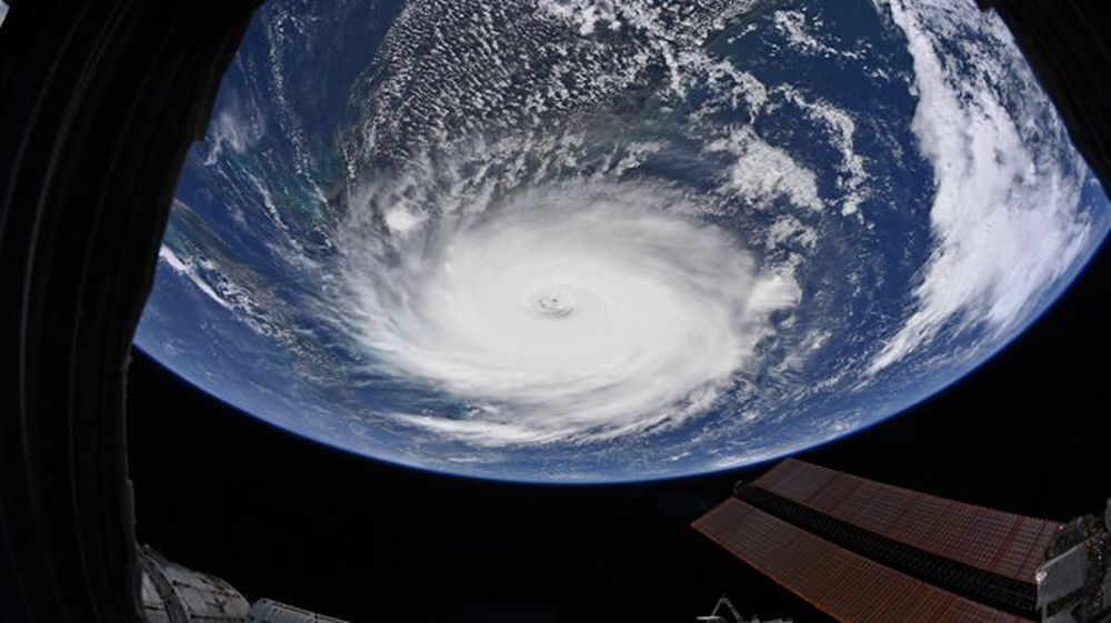
A hurricane is born when the wind speed within the tropical storm exceed 74 mph. At this point, towering thunderstorms rapidly form near the center where there is rapid rising motion. An eye may develop in the center of the hurricane. There is a saying “what goes up must come down” and all the air comes down in the center of the storm. As air sinks in the center, it forms a clearing and if one were to stand outside in the eye of the hurricane, you may be able to see the sun. The eyewall surrounds the eye of a hurricane and the eyewall is the most dangerous part of any hurricane. This is where the tallest, most severe thunderstorms are located. This is where the winds are strongest in any hurricane and it can cause catastrophic damage.
A hurricane’s strength is rated on the Saffir-Simpson scale, ranging from category 1 to category 5. This is a function of sustained wind speed and is as follows:
• Category 1: 74-95 mph
• Category 2: 96-110 mph
• Category 3: 110-129 mph
• Category 4: 130-156 mph
• Category 5: 157 mph and above
Category 5 hurricanes are rare but when they do happen, it can cause total destruction and completely obliterate anything in its path. These storms are to be taken very seriously. Hurricanes can produce tornadoes, flooding from heavy rain, storm surge flooding, and catastrophic damage. A major hurricane is classified as a category three hurricane or stronger.
A hurricane will lose its intensity quickly after making landfall. Once you remove one of the key ingredients like warm water, humid air mass, or weak upper level winds, the hurricane will weaken.
Experiment: How Hurricanes Form
Purpose: To demonstrate how hurricanes form with a circulation
What you need:
- A clear glass mixing bowl is best but any bowl will work
- Water
- Blue food coloring
- Stirring rod
- Shaving Cream
Procedure:
1. Fill the bowl a little more than half way with water
2. Use the stirring rod and stir the water around counterclockwise
3. Take the food coloring and put a few drops at the center
4. Observe the shape the food coloring takes
5. Stir again
6. Add shaving cream down the center. The shaving cream will act as towering storm clouds as seen on a weather satellite
7. Stir for another 10-15 seconds
8. Observe shape of “storm clouds”
Results: The food coloring immediately dispersed into a circular pattern, rotating faster in the center and slower on the outside. The shape took on a saw blade look with an “eye” and feeder bands going toward the center.
Conclusion: From this experiment, it can be concluded that the circulation is tighter and faster toward the storms center. The shape of the food coloring closely resembles the shape of a hurricane when viewed from a weather satellite. You can see the outer bands rotate around the circulation. Once the circulation weakened, the bands became less defined. This symbolizes the death of the hurricane. The purpose of the shaving cream is an added bonus. The shaving cream will form a similar shape and would closely resemble what a hurricane looks like on a visible satellite.


