


ORLANDO, Fla. — Tropical Storm Michael continues to strengthen in the western Caribbean, and a direct impact to the Florida Panhandle continues to increase.
- System now Tropical Storm Michael
- TS likely to make landfall in Florida Panhandle
- TRACKING THE TROPICS: Watches, warnings, forecasts, spaghetti models
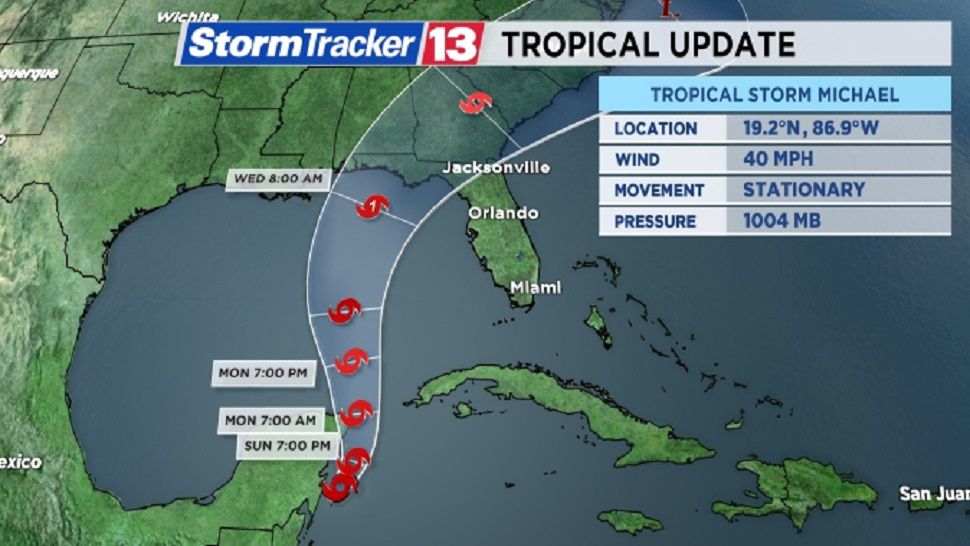
Michael is located 130 miles south of Cozumel, Mexico. Maximum sustained winds are at 60 mph.
The system is moving to the north at 5 mph. The minimum central pressure has dropped to 997 mb.
Tropical Storm Warnings continues for parts of western Cuba and the Yucatan Peninsula in Mexico.
The following advisories are in effect:
A Tropical Storm Warning
* The Cuban Provinces of Pinar del Rio and the Isle of Youth
* The coast of Mexico from Tulum to Cabo Catoche
Tropical storm force winds extend outward up to 175 miles from the center.

The storm will spread tropical storm force winds across western Cuba over the next 12 hours. Rainfall of 3-7 inches is possible in western Cuba, with 2-4 inches of rainfall possible on the Yucatan Peninsula, Belize and Honduras. Isolated amounts of 12” of rain are possible in western Cuba.
Rainfall amounts of 2-4 inches are also possible in the Florida Keys from the outer rain bands of Michael.
The system will lift northward into the Gulf of Mexico. From there, Michael will likely make landfall along the northern Gulf coast as a Category 1 or 2 hurricane Wednesday or Thursday.
The likelihood of a direct strike in the Florida Panhandle is becoming likely, with wind, storm surge and heavy rainfall all major threats. Hurricane Watches will likely be posted on Monday for parts of the Panhandle and North Florida.
There remains high uncertainty about the possible intensity of the system, but Michael will drag tropical moisture across Florida. This will increase the rain chances across the entire peninsula for the middle of the upcoming week.
Winds will also remain breezy across Central Florida over the next few days, but the worst wind and rain is expected to stay west and northwest of the area.
Michael was upgraded to a tropical storm early Sunday afternoon. It becomes the thirteenth named storm in the Atlantic this season.
Tropical Storm Leslie

Elsewhere in the tropics, Tropical Storm Leslie has weakened slightly in the open waters of the Atlantic.
Leslie continues to produce rip currents and large swells across the US east coast, including Florida.
The storm is located about 930 miles east-northeast of Bermuda. This storm does not pose a threat to Florida or the U.S., but large swells will likely continue over the next 2-3 days.
Leslie sustained winds are at 50 mph and are now moving to the east-southeast at 13 mph. The minimum central pressure is 989 mb.
Tropical storm force winds extend outward up to 230 miles from the center.
Leslie will continue to move to the east and then southeast over the next several days, taking Leslie across the central and eastern Atlantic. The system will remain a tropical storm for the next several days, but could be near hurricane strength on Wednesday or Thursday.
A third area of interest has formed in the eastern Atlantic near the Azores, but this system has a low chance of development. It has a small chance to develop into either a subtropical or tropical storm.
Hurricane season runs through Nov. 30.