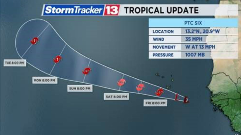
ORLANDO, Fla. -- Potential Tropical Cyclone Six formed Thursday morning in the extreme eastern Atlantic, as Tropical Storm Warnings have been issued for the southern Cabo Verde Islands.
- Potential Tropical Cyclone Six is not expected to impact US
- TODAY'S FORECAST: Heavy rain, storms expected Thursday
- SEE BELOW: Keeping an eye on tropical wave in the Caribbean ▼
- TRACKING THE TROPICS: Watches, warnings, forecasts, spaghetti models
The system is located approximately 260 miles east-southeast of the southernmost Cabo Verde Islands.
The potential tropical cyclone has winds of 35 mph. It is moving to the west at 13 mph.
A potential tropical cyclone is a system that is not yet a fully formed tropical cyclone, but will likely become one in the next 24-48 hours. A potential tropical cyclone also allows watches and warnings to be issued.
Tropical Storm Warnings have been posted for southern Cabo Verde islands, including:
- Santiago
- Fogo
- Brava
Potential Tropical Cyclone Six is expected to gradually strengthen into a tropical storm early Friday. When it becomes a named storm, its name will be ‘Florence’.
Tropical storm conditions are expected along the southern Cabo Verde islands on Friday, with 4-8” of rainfall also likely.
The system is then expected to move away from the islands and intensify into a hurricane early next week. Models turn this system north before getting anywhere near the United States.
At this time, the potential tropical cyclone is not expected to impact the United States.
Tropical wave in the Caribbean

Elsewhere, we are watching a tropical wave sitting between Puerto Rico and the Dominican Republic that is producing heavy rainfall across parts of the Caribbean.
This is expected to move northwest over Cuba and into the Gulf of Mexico early next week. Once it’s in the Gulf, there is a low chance of tropical development. While formation of a tropical system is very low, enhanced rainfall across the state is likely.
Atlantic hurricane season runs through Nov. 30.


