We’ve all heard the saying “April showers bring May flowers,” but when do we see the biggest deluges and downpours? It’s not April.
The warmer summer and fall months hold most of the 24-hour rainfall records, with Hawaii and Texas at the top of the list.
Hawaii is home to the wettest 24 hours on record in the United States, and that record happened in April 2018. 49.69 inches of rain fell in Waipā Garden in Kauai between April 14-15.
Not only did it break Hawaii’s previous rainfall record, but it broke the United States rainfall record that belonged to Alvin, Texas.
Texas still holds the record for the contiguous United States. In July 1979, Tropical Storm Claudette brought torrential rainfall to parts of the Gulf Coast, including southeast Texas.
An observer just west of Alvin measured 42 inches between July 25-26, 1979, and that may be under-reported by a few inches after the rain gauge began overflowing during the storm.
Texas isn’t the only state where a tropical system set a 24-hour rainfall record. At least 16 other state records are from tropical depressions to major hurricanes.
Among those records, Hurricane Floyd in 1999 holds three state records: South Carolina, Vermont and Virginia. Hurricane Lili in 1996 broke two state records: Maine and New Hampshire, and Hurricane Diane in 1955 broke two: Connecticut and Massachusetts.
There is no official state record for Kansas since the previous record turned out to be an error, so an investigation for the record is ongoing.
Even though the saying about April showers is catchy, it’s more about snow turning to rain in the spring than seeing heavy rainfall.
We’ve only seen one rainfall record set in April, and coincidentally, it’s Hawaii’s U.S. record. Otherwise, we see most records set during the summer or hurricane season.
Warm air can hold more moisture than cold air, and a lot of times during the winter when there are big precipitation events it’s not rain, but snow rather. More than half of the 24-hour rainfall records are during meteorological summer (June-August).
After summer, fall comes in second place, thanks to the increased tropical activity during late summer and early fall, with mid-August through mid-October being the peak in activity during an average year.
When looking at the biggest 24-hour rainfalls by decade it’s pretty evenly spread out except for one that sticks out - the 1990s.
Mentioned earlier, Hurricane Lili in 1996 and Hurricane Floyd in 1999 accounted for five records, but the total more than doubles the next closest decade.
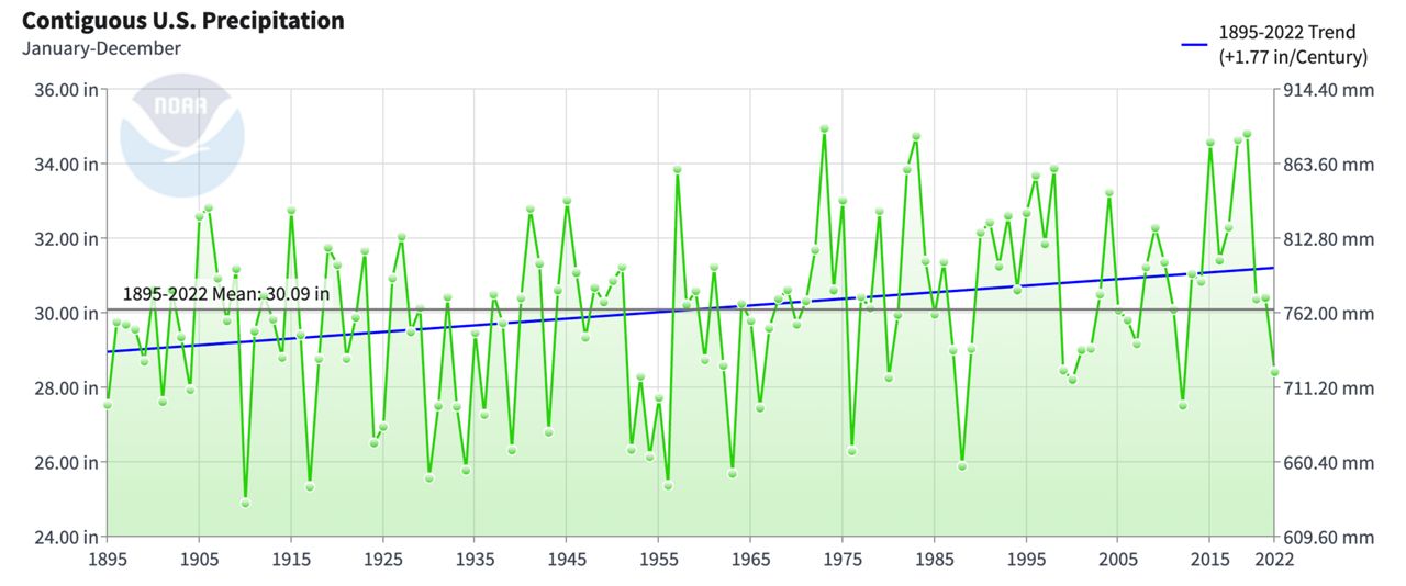
Looking deeper into the average annual contiguous U.S. precipitation from 1895 to 2022, you can see the 1990s were just a wetter period in general.
Between 1895-2022, the average annual precipitation is 30.09 inches. Between 1990-99, the average was 31.97 inches, almost 2 inches more.

1999 is the only year in the entire decade that posted below normal precipitation. Rainfall is still highly variable on a year-to-year scale, but climate change in a warming world is a link to more heavy precipitation events.
According to NOAA and the EPA, “Climate change can affect the intensity and frequency of precipitation. Warmer oceans increase the amount of water that evaporates into the air. When more moisture-laden air moves over land or converges into a storm system, it can produce more intense precipitation—for example, heavier rain and snow storms.”
Our team of meteorologists dive deep into the science of weather and break down timely weather data and information. To view more weather and climate stories, check out our weather blogs section.
Reid Lybarger - Digital Weather Producer
Reid Lybarger is a Digital Weather Producer for Spectrum News. He graduated from Florida State University in 2015 with a Bachelor's of Science in Meteorology. He began his career in local TV news working across Mississippi, Louisiana and Florida for 7 years prior to joining Spectrum in 2022. He's excited for the opportunity to continue to inform the public about the latest weather news with Spectrum.


